FLASH service brings flood resilience to Parramatta
The challenge
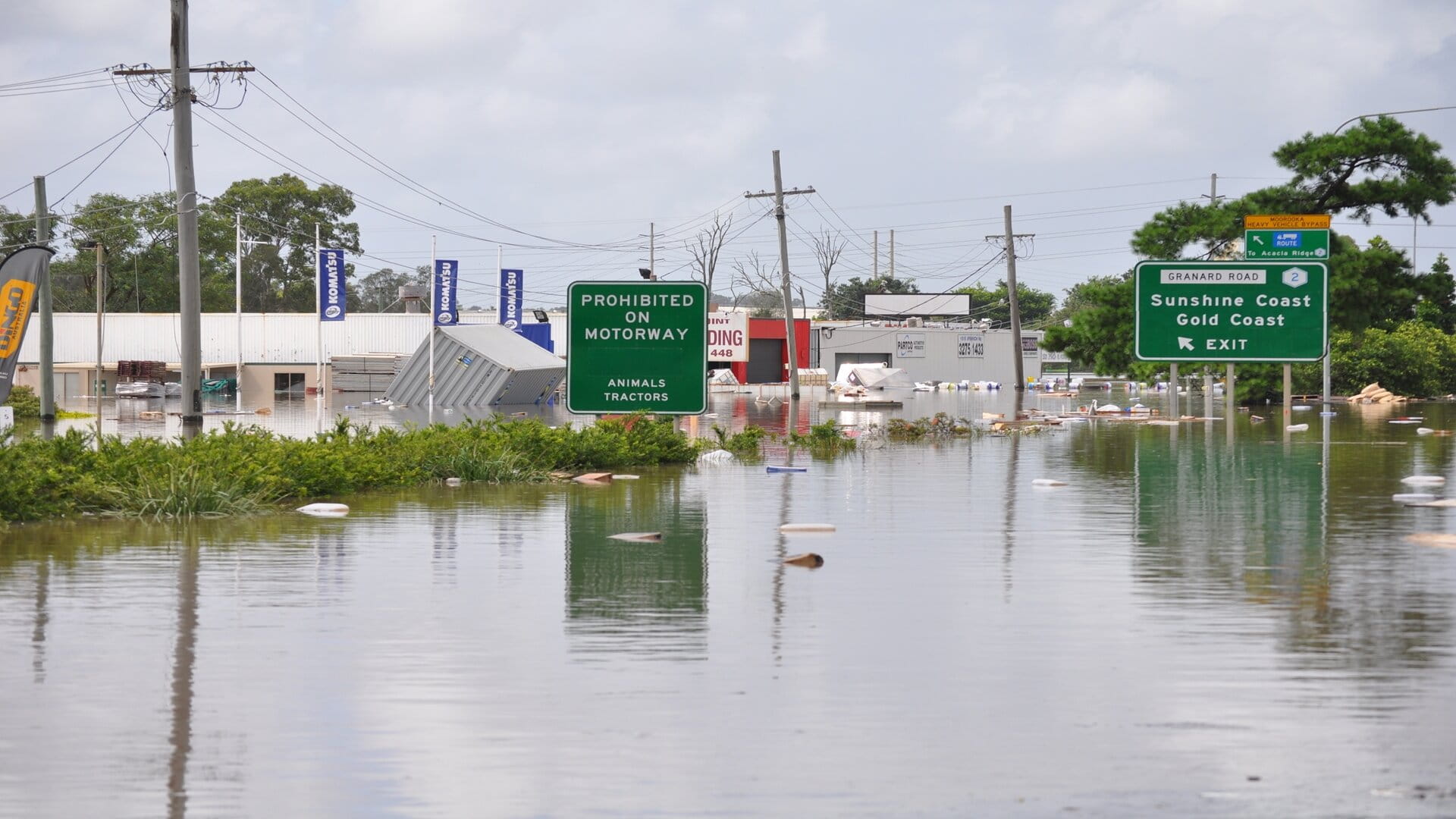
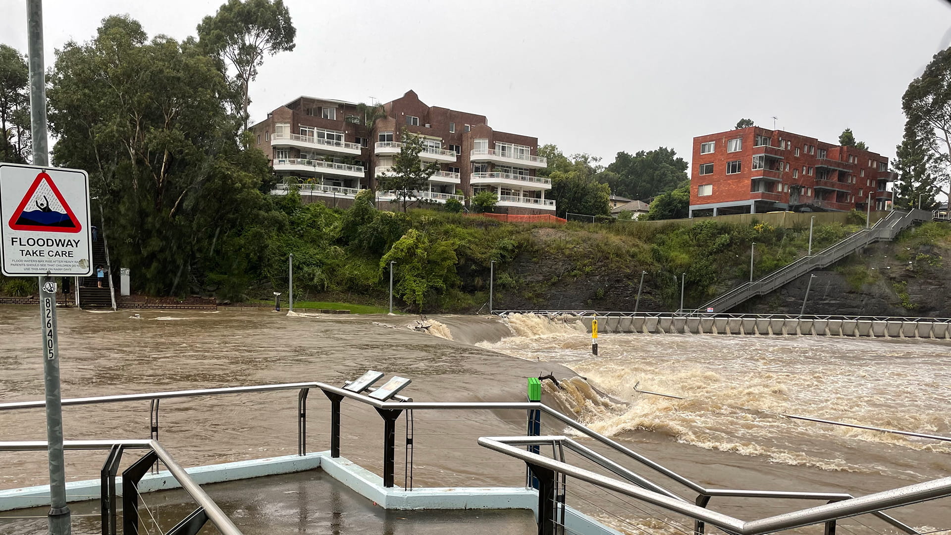
The Parramatta River plays a big part in the city’s economic, social and recreational life. But it also presents a major challenge to the city’s council, in the form of flash floods that occur during periods of heavy rainfall.To ensure residents remain safe, the council needs to be able to forecast flood events and mitigate their impacts. But predicting a flash flood is far from easy. Typically, these events occur seemingly without warning, giving emergency responders and residents very little time to prepare.
“Minor incidents can impact on recreational areas a number of times each year,” says Chris Gooch, Senior Flood Project Officer at the City of Parramatta Council. “However, there is the potential for more extreme flooding to occur, like in 1986 and 88. These events cause significant flooding of properties, the Central Business District and the surrounding communities.”
The council recognised that traditional monitoring solutions were not fit for purpose when it came to tackling flash floods. Instead, to keep residents safe, it would have to explore new ways of providing early warnings to those who needed them.
The FLASH service allows us to be much more responsive to extreme weather events. We can quickly and easily see the impact that heavy rainfall will have on our communities.
“Previously, forecasters would have to rely on disparate rainfall gauges, water level gauges and datum systems, and then bring that information all together,” says Ben Patterson, Associate Director of Royal HaskoningDHV Australia. “That could take hours, if not days. And with flash flooding, that’s just far too late.”
The FLASH service uses state-of-the-art rainfall forecasting systems developed by the BoM, along with 3Di hydraulic models that predict water level rises in the river over the next 12 hours.
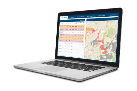
The solution produces a new flood impact forecast every thirty minutes, and displays results in an intuitive dashboard that allows emergency responders and government officials to access all their important information in one place.
As a result, the city is able to respond to imminent flooding events in a matter of minutes, closing roads, informing emergency responders and sending flood warnings to the public.
The solution
With this goal in mind, the City of Parramatta Council engaged Royal HaskoningDHV to develop an advanced flood warning solution for the upper Parramatta River, including the Parramatta Central Business District.Working in close consultation with key stakeholders, including the Bureau of Meteorology (BoM) and the Sydney Water Corporation (SWC), Royal HaskoningDHV implemented an innovative flash flood forecasting service, named FLASH.
The tool is designed to provide warnings far earlier than other solutions are able to – and ensure the right people have the right amount of time to respond to threats.
“Previously, forecasters would have to rely on disparate rainfall gauges, water level gauges and datum systems, and then bring that information all together,” says Ben Patterson, Associate Director of Royal HaskoningDHV Australia. “That could take hours, if not days. And with flash flooding, that’s just far too late.”
The FLASH service uses state-of-the-art rainfall forecasting systems developed by the BoM, along with 3Di hydraulic models that predict water level rises in the river over the next 12 hours.
The solution produces a new flood impact forecast every thirty minutes, and displays results in an intuitive dashboard that allows emergency responders and government officials to access all their important information in one place.
As a result, the city is able to respond to imminent flooding events in a matter of minutes, closing roads, informing emergency responders and sending flood warnings to the public.
The result
The FLASH service has been operational in Parramatta since 2018 under the moniker Floodsmart. Its implementation has resulted in an almost real-time view of flooding conditions, increased lead time for responders and invaluable decision support for the city council.Furthermore, the tool is now directly available to all other councils in Australia, fully supported by data from the BoM.
Like Parramatta, these councils will benefit from lightning-fast calculation and rapid processing of real-time and predicted rainfall data. They will also be able to access insights from any device and any location via the cloud.
“To provide these insights in real time requires a series of complex algorithms, calculating at a speed to produce results in under 15 minutes,” says Patterson. “Past models were producing results in up to six hours, which is just not helpful in urgent situations.”
The city of Parramatta now uses its timely flood information to provide custom warnings to different groups of people. It also uses the tool’s automated post-event reports to further improve responses to flash flood events.
Vitally, armed with this crucial information, the council is now able to be proactive rather than reactive with its responses.
“The FLASH service allows us to be much more responsive to extreme weather events,” says Gooch. “We can quickly and easily see the impact that heavy rainfall will have on our communities. This allows our council to plan and prepare more effectively. Before, it was ‘how do we respond to what’s happening?’ Now, it’s ‘how do we plan for what’s predicted?’”
Find out yourself
Want to know moreor got a question?
Contact our Climate Resilience experts!